
DA62 for Special Missions

The Diamond DA-62 is a well-known, 7-seat twin-engine aircraft, and this model is becoming increasingly common in Poland. The MPP (Multi-Purpose Platform) is a variant of this aircraft designed for special missions, and for some time now, we have been seeing aircraft in this configuration bearing Polish markings.
Aircraft used for aerial photography or terrain scanning, equipped with additional sensors and cameras, have always piqued my interest. On the one hand, they are common aircraft, but they’re built differently and feature additional equipment hidden in the fuselage or suspended under the wings. When I heard from Kuba Śliwiński that he flies a Diamond DA-62 MPP, I couldn’t pass up the opportunity to take a closer look at this aircraft and the types of missions it’s used for.
We meet at the airport in Modlin, near Warsaw, which is one of the bases of OPEGIEKA—the aircraft’s owner—a company specializing in aerial surveying and imaging. After taking care of a few formalities, we arrive at the hangar, where Czarek—the systems and sensors operator for this aircraft—is waiting for us. Together, we head to the plane to take a closer look at it and learn about the differences compared to the standard version.
A First Look at MPP
This may be a subjective impression, but the MPP variant is impressive. This is especially true of the version installed on the DA-62, which is already a larger aircraft. There are quite a few differences, both on the outside and on the inside—it’s worth noting that each DA-62 MPP can have a different configuration and equipment, tailored to specific orders.
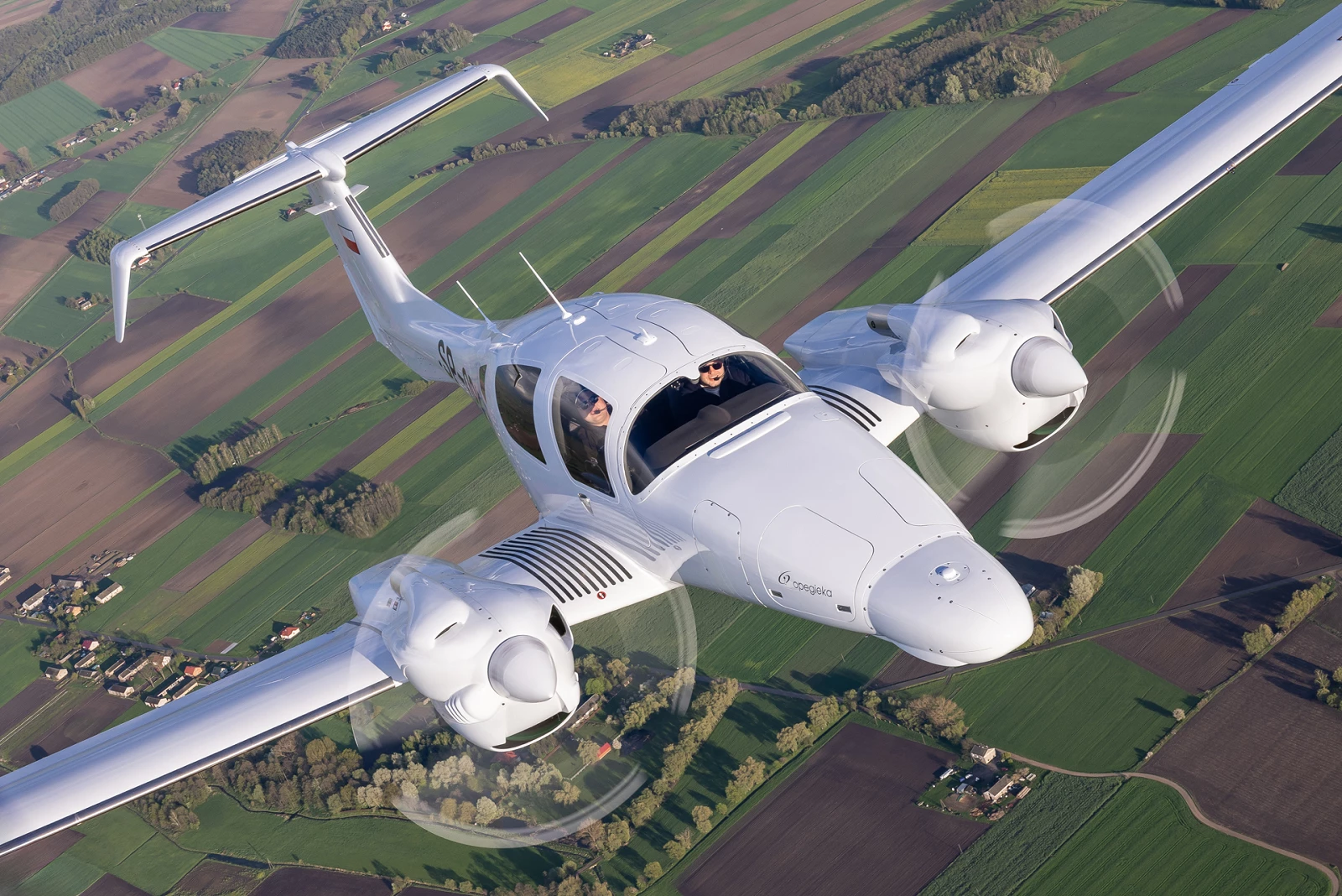
The first thing that definitely catches the eye is the elongated nose—it houses a weather radar and provides space for mounting an additional LIDAR scanner or an optoelectronic sensor. This not only allows for safe flight through clouds but also increases the amount of data collected during a single flight.
Another feature is the elongated, downward-pointing tips of the horizontal stabilizer—they improve the aircraft’s stability in flight. As Kuba explains, “When flying for aerial photography, we have to follow a designated route very precisely, with very little tolerance and almost no wing bank. We fly with greater precision than with a factory-installed autopilot, which is why our aircraft’s stability is a very important factor.”
![DA62_SPOPK_20240416_4348.jpg [1.33 MB]](https://www.jbi.com.pl/storage/image/core_files/2026/9/30/695de165612b35d6e27c15bcf211ca5c/jpg/jbinvestments/preview/DA62_SPOPK_20240416_4348.webp)
Dual drive
The airframe looks the same as in the classic version, but the Austro Engine AE330 engines, each with 180 KM of power, are worth noting. An interesting design feature is the redesigned exhaust outlet, which is located at the top of the nacelle instead of the bottom. This change was made to prevent hot exhaust gases from the engine from blurring photographs or interfering with aerial measurements taken by sensors located beneath the fuselage.
The DA-62 uses JET-A1 fuel, which not only helps reduce costs but also improves availability—while AVGAS is fairly readily available in Poland, JET-A1 is by far the more popular fuel across Europe. Its low fuel consumption is also noteworthy—when flying at a reasonable speed (75% power), fuel consumption is only 14.8 US gal/hour, and by reducing the cruise speed, fuel consumption can be kept at 8–9 US gal/hour. This performance exceeds that of some popular single-engine aircraft and allows for flight missions lasting up to 8 hours non-stop.
It’s also worth mentioning the ease of use offered by single-lever technology—the DA-62 features a FADEC system in each engine, and the cockpit has only two levers used to control power in percent. There’s no need to adjust RPM or fuel flow; the computer system does it all for us. “Engine checks and takeoffs are very simple and performed with the push of a single button, and my favorite feature of this aircraft is the engine RPM synchronizer—in other aircraft, there can be a difference of about 20 RPM, which causes an unpleasant noise during flight. In the DA-62, the RPMs on both sides are synchronized to enhance flight comfort and stability,” adds Kuba.
![DA62_SPOPK_20240416_4228.jpg [1.12 MB]](https://www.jbi.com.pl/storage/image/core_files/2026/9/30/1029aa96e7ffa9637d09dcde072a7c22/jpg/jbinvestments/preview/DA62_SPOPK_20240416_4228.webp)
On board
Upon entering the cockpit, the modern Garmin G1000NXi avionics immediately catch the eye, which definitely makes the pilot’s job easier. The ergonomics are also impeccable—when you sit in the pilot’s seat, you feel truly comfortable and spacious; there’s none of that cramped feeling you get in other, smaller aircraft. Compared to the “classic” DA-62, everything looks the same, and from the pilot’s perspective, the only difference is the additional “Mission Master” switch, which allows you to activate all the auxiliary systems.
The MPP version of the DA-62 has larger built-in alternators to ensure sufficient power for all additional components. It’s worth noting that this DA-62 model does not have a built-in air conditioning system, an oxygen system, or an ADF. This aircraft is designed for flights below 12,500 ft, and its main goal is to increase available flight time, which is why every kilogram matters here. Eliminating these systems saved approximately 50 kg, which translates to over 1 hour of additional flight time.
![DA62_SPOPK_20240416_4568.jpg [1.36 MB]](https://www.jbi.com.pl/storage/image/core_files/2026/9/30/6855881b36358ae73fe4892719daefbb/jpg/jbinvestments/preview/DA62_SPOPK_20240416_4568.webp)
Sensors, cameras, and computers
Looking toward the rear of the cabin, you can see many more differences here. I mentioned at the beginning that the DA-62 is a 7-seat aircraft… The SP-OPK is a 3-seat version, and the space next to the operator is occupied by the Leica CityMapper S2 system—the only one of its kind in Poland—which is supported by artificial intelligence and real-time data analysis in proprietary software designed by OPEGIEKA.
Czarek, who has been a systems operator on various aircraft for several years now, steps in to help and explain. “CityMapper is a hybrid system that helps us take not only vertical photos but also oblique ones at a 45-degree angle. It’s also equipped with a LIDAR scanner, which allows us to create 3D maps with an accuracy of 2 cm. The onboard computer, which takes up the entire space behind the operator, continuously analyzes the photos as they’re taken, checking for things like cloud shadows, image blur, and proper exposure. We use artificial intelligence for this, which helps us take the right photos without having to return to the same spot if we discover a problem during post-production.”
The operator has two screens in front of them for monitoring and observing the system, as well as the ability to resolve any errors that may occur in flight. To streamline the operator’s work and ensure the pilot’s comfort, an additional “Operator Overhead Panel” is built into the ceiling, allowing the operator to reset individual devices. The pilot also has an additional screen in the front that displays the system status and route.
![DA62_SPOPK_20240416_4693.jpg [1.38 MB]](https://www.jbi.com.pl/storage/image/core_files/2026/9/30/33429b71bf468a6d538795fcaad97f68/jpg/jbinvestments/preview/DA62_SPOPK_20240416_4693.webp)
Missions, Flights, and Measurements
With all the equipment on board, it is clear that this particular aircraft, with the registration SP-OPK, performs nearly all of its flights as part of survey missions. It is worth noting that this aircraft and its onboard systems were purchased with support from European Funds. The investment was part of a project titled “Implementation of New Technology for Remote Sensing Analysis of Image Data,” carried out under the European Funds for a Modern Economy 2021–2027 Program, Measure 2.32 Technology Loan, Priority 2: An Environment Conducive to Innovation.
The DA-62 MPP, like other aircraft in the OPEGIEKA fleet, operates flights throughout Europe—they can be found not only in Poland, but also, for example, in the Netherlands, Sweden, Estonia, and Greece, and their primary mission profiles involve photogrammetric flights over selected areas. These may involve specific cities and vertical or oblique photographs, or they may involve 3D models of specific areas, forest cover surveys, or high-voltage power line surveys—there are numerous possibilities and applications for aerial imagery.
There is always a pilot and an operator on board, and most flights are conducted at altitudes ranging from 5,000 to 8,000 ft. Mission planning begins with checking the weather—“To take photos, we need either full cloud cover or no clouds at all; the goal is to avoid shadows on the ground and any overexposure in the images. “When flying with the LIDAR scanner, we can fly in almost any weather, provided there are no clouds below us and no precipitation,” says Czarek.
From a pilot’s perspective, these flights are very demanding due to the extremely high precision required; a comfortable and easy-to-fly aircraft definitely helps here. “When flying along a predetermined route to take photos, we have a very small margin of error—±30 m relative to the required position and ±10 m relative to altitude.” At first, I thought a good autopilot could maintain such an accurate track, but when flying the aircraft manually, we achieve much greater precision by making very subtle corrections with the controls. We usually make these adjustments with our feet (using the rudder), unlike the autopilot, which changes the flight path by using the ailerons to tilt the wings. “We want the wings to be level, since we usually take photos looking down,” adds Kuba. Typical missions last between 3 and 5 hours, and the onboard operator is responsible not only for operating the onboard systems but also serves as an extra set of eyes for the pilot.
The DA-62 MPP is definitely a unique aircraft with a wide range of applications. It’s encouraging to see that more and more aircraft of this type are being added to the Polish registry and that more and more pilots are flying them—let’s hope this trend continues.
Text and photos:Filip Modrzejewski


